Navigation
These terms apply to the instructions given in this help:
- Click: means click the left mouse button
- Right-click: means click the right mouse button
GIS toolbar icons
Navigation icons are located in the GIS toolbar, directly above the map, and these apply to all of the map screens:
-
 + click: Zoom in
 - + right-click: Zoom out
-
 + drag click: Pan
 -
 Reset GIS: Note that this zooms to extents.
 -
 Selection pointer: Single or group selection is available. For group selection, you can select by:
- Area (right-click and drag for a rectangular box selection around the facilities you want to select)
- Lasso (right-click and drag to draw a free-form polygon around the facilities you want to select)
Shortcut keys
- Esc: resets the mouse to the default pointer (instead of link connections, reconnect, drawing a facility, zooming, panning)
- Shift + right-click: Zoom in
- Shift + drag right-click: Zoom in on rectangle
- Ctrl + right-click: Zoom out
- Shift + drag click: Pan
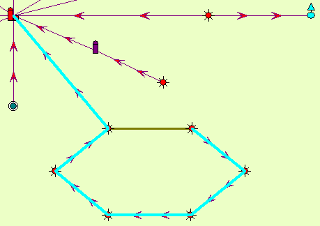
- Ctrl-L: toggles link highlighting
Ctrl-L toggles link highlighting on / off. When this is turned on, links will appear as blue lines that trace their way back to the plant. In the case of a loop line, it shows an orange line in addition to the blue line which represents the different pathways that can be taken to get to the plant. The blue line is drawn first, so if there does not seem to be a blue line to the plant, it is being obscured by the orange line.